We left home early a week ago Saturday and trying to beat the heat of the Mohave and the Utah desert, drove for two long days before arriving in the Rocky Mountains. We found a campsite of sorts in a national forest camp that consisted of a parking lot on the shores of Dillon Reservoir, which is just off of I-70 and about 70 miles east of Denver. The upside to this "camp" was its location.

Great views of the lake and the mountains beyond and close to the towns of Frisco, Dillon and Silverthorne. Take a good look at the blue sky in the photo taken the day of our arrival. The next four days it rained. But this is what is expected when we travel, the rain finds us.
The State of Colorado is not only home to legalized marijuana, but miles and miles of paved bike trails. We discovered several years ago that there were over 500 miles of these trails in the Denver area. Around here in the Rockies is no different, with paths connecting the towns in the area. I noticed a bike path alongside of I-70 most of the way over the Rockies. I had expected to ride some of these trails, but wimped out due to the rain.
Hiking trails abound here, mostly heading uphill. There are several 14,000 + peaks in the area, commonly referred to as 14 teeners, but they will have to wait for another time. We did manage to get in one hike between rain showers on a loop trail around Cataract Lake. A beautiful lake at about 9,000 feet.


Next we opted to forgo the interstate and stuck to the secondary routes heading north. We stopped off at State Forest State Park, which is just south of the Wyoming State line. An area known for spotting moose, but of course we didn't see any. While on a backcountry hike we happened upon a herd of elk, which heard us before we saw them. There we about 20 of them and they were up and over a ridge before I could get the camera out. I did manage to get a shot of a straggler who hung back to check us out.

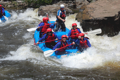
Friends and fellow bloggers, Don and Dorothy were in the region recently and wrote of their discovery of the Cache La Poudre River Canyon just west of Fort Collins. (You can read their blog HERE.) Their description of the area was such that we just had to check it out. By heading west on Colorado 14 we climbed up over the Continental Divide and into the aforementioned canyon. The road drops some 5,000 feet in 50 miles as it follows the Cache La Poudre River. Campsites are plentiful as are the folks who occupy them, but by arriving on a Sunday many were returning home and we managed to snag a nice spot within earshot of the river. Cache La Poudre is French for "hide the powder, so named when in the 1820's French trappers, caught by a snowstorm were forced to bury part of their gun powder along the banks of the river. Today the river is popular with fishing, rafting and kayaking.

We paid a visit to Deadman Fire Lookout, now a National Historic Site. The tower has not been permanently staffed since 1970, but is operational and open to the public in the summer thanks to a crew of volunteers. The original wooden tower was built by the CCC in 1937 and was said to have swayed in the wind. It was replaced by the current metal structure in 1961. At a height of 55 feet to the lookout platform and an elevation of 10,710, I managed to overcome my fear of heights. I only made it to the top by white knuckling the stair rails and keeping focused on Cathie's derriere as she led the way. There is proof that I made it to the top as I took this photo of Cathie in the lookout.

We are now in Greeley, Colorado for three days to resupply, do laundry and hopefully get some bike riding in. There is a great 21 mile bike path along the Cache La Poudre River between here and Fort Collins. Let's hope it doesn't rain.
1 comment:
The next time I need to climb a fire tower, I want both Cathie and Dorothy ahead of me for inspiration. Hope you leave the wet stuff behind. Still on the Oregon coast for another week or so.
Post a Comment