
It’s been hot in San Diego for a while now, so I figured I needed to go somewhere where the weather is different. I chose Death Valley. Well actually I chose a mountain in Death Valley National Park. At just over 11,000 feet, Telescope Peak in the Panamint Range just west of Bad Water. The peak is the highest mountain in the park and in the Panamint Range from it you can see the lowest point in the United States. And I might add, at 11,000 feet, it’s cooler than Bad Water and San Diego.
I had been considering this hike for some time now and figured I better do it now, as later in the year, snow becomes an issue. Also it was my birthday and as a present to myself I wanted to do this hike. Friend Mike was going to tag along, but had to cancel at the last minute due to a family emergency. Since the trip was planned, I decided to go it alone.
Getting to the trailhead requires a six hour drive to Death Valley National Park. You drive up Wildrose Canyon passing the Wildrose Canyon Charcoal Kilns. Built in 1877 by the Modock Consolidated Mining Company, they provided charcoal for the mine smelter. The last 1.5 miles to Mahogany Flats Campground and the trailhead required 4 wheel drive as the dirt road was severely damaged in recent thunderstorms. At just over 8,000 feet, I spent the night in order to acclimate to the altitude. After I arrived and set up camp, another couple arrived who had the same intent as me. I felt a little better known someone else would be on the trail.

CHARCOAL KILNS IN WILDROSE CANYON

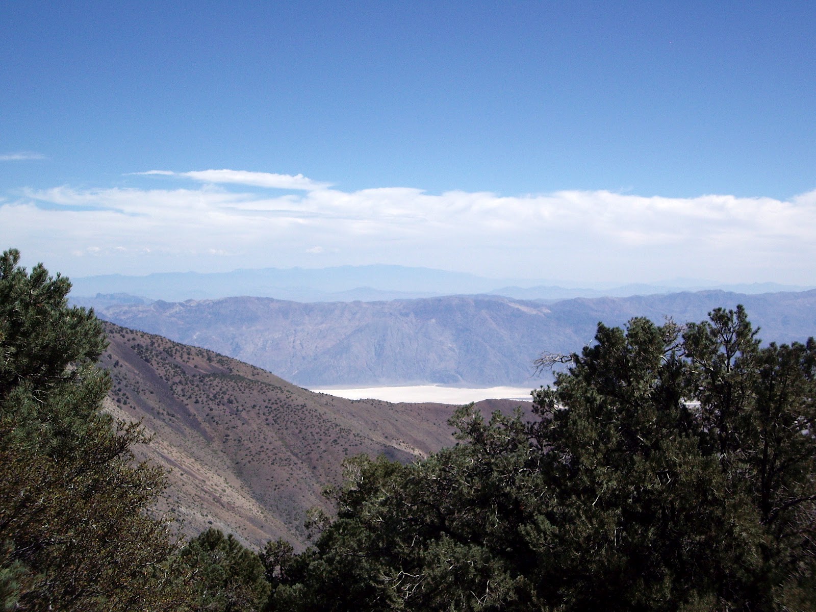

DEATH VALLEY VIEW
The wind really blew most of the night, but I slept well in spite of the tent rattling. I got up early, had breakfast and started up the trail at 6:30. As a testament to the wind, the sign pointing the way had blown down during the night. As I climbed I watched the sunrise over Death Valley, my photo of which turned out blurry so it's not here. Because of the wind, the views were hazy and full of dust, which was a disappointment. The first 2 miles of the hike are continuously up hill and because the trail traverses the eastern slope of the mountains I was protected from the wind. After 2 miles the trail levels out, with view to both the east and west. No longer protected from the wind I started getting cold. Although the air temperature was probably in the high 40's the wind chill had to be near freezing. My hands got so cold that I needed to put on my heavy winter gloves. I’m glad I came prepared. With the wind like it was, I was a little concerned about how bad it would be on the summit.

STEADY UPHILL

FIRST VIEW OF THE SUMMIT
Once reaching this first saddle, the trail levels out and traverses Arcane Meadows, skirting round the western slope of Bennett Peak. The trail stays level for about 2 miles before starting it’s final ascent to Telescope Peak. The old route followed the ridge up to the summit, but the new trail stays on the eastern side of the mountain, climbing up 13 switchbacks. (Yes I counted them). This kept me out of the wind and the climb was less steep. I didn’t say it wasn’t steep, just less steep. As I topped the ridge I could see the summit about ¼ mile away. The wind stopped for my birthday and it was quite pleasant following the ridge to the summit.

ARCANE MEADOWS

SUMMIT IN THE DISTANCE

GETTING CLOSER

JUST ONE MORE MILE

SUMMIT IN SIGHT!
Although there was no wind for my 30 minute stay on the top, the views were marred by the haze. I had taken me 4 hours to make the climb. The official mileage is 7 miles, but my GPS showed it at 6.2 miles. I have read other accounts of the climb, and 6.2 or there abouts was reported. I had the summit to myself, signed the register and had lunch before heading back down. On the way down I met a couple from Canada on their way up. Never did see the couple who was camping at the trailhead. I guess they chickened out.

HAZY VIEW OF DEATH VALLEY

JUST TO PROVE I WAS THERE
I made it back to the car at about 2:00 and after a sandwich, I headed to Lone Pine for a shower at the Mt. Whitney Hostel. For $5 you get a towel, soap and can stand under the hot water for as long as you like. After getting cleaned up, I drove to Independence and found a place to camp at Gray’s Meadow beside Independence Creek. After dinner it was off to bed by 9:00.

Up early the next morning, because when you go to bed at 9, you’re wide awake by 5 and also I had another hike planned. After breakfast, I drove to the trailhead at Onion Valley just up the road from where I camped. Cathie and I had hiked here last year, but due to a heavy snow pack we didn’t get far. The plan was to climb to Kearsarge Pass at 11,760 feet affording spectacular views into Kings Canyon National Park. According to the written description in a book I have, it indicated that it was an 11 mile round trip, with and elevation gain of just over 2600 feet. Turns out the written description is wrong again as my GPS showed the round trip mileage at 9.5 miles. The climb to the pass was steady so it wasn’t too steep. Higher than Telescope by about 700 feet, it was an easier hike. The views on the way up were only topped by the view into Kings Canyon Park.

SIERRA SUNRISE

HEART LAKE ON THE WAY UP

THE PASS IS IN VIEW
LEFT SIDE OF PHOTO
JUST TO THE RIGHT OF THE BUMP
This is a popular trail and although not crowded, you do run into people. On the way up I could look back and I kept seeing this one person. You could tell he was moving fast and every time I saw him he was getting closer. I figured it must have been some young stud by the speed he was traveling. Finally when he caught up with me, he was just another old guy my age. We exchanged greetings as he passed and I thought that if I could get right behind him, his slipstream would help me up the hill. Such was not the case as I couldn’t go fast enough to get that close behind him. He reached the pass about ½ mile ahead of me.

FAST HIKER (JIM) WENT WHIZZING BY
When I did reach the pass, introductions were made and I learned that Jim, the same age as me, was from West Virginia and since retiring about 5 years ago makes a two week trip to the west every year for the sole purpose of hiking. He said besides Zion, the Eastern Sierras is his favorite place to hike. He told me of the places he had hiked on this trip and many were places I too had hiked.

ALMOST THERE


THE PROOF I WAS THERE SHOT

INCREDIBLE VIEWS

OVERLOOKING BIG POTHOLE LAKE

HEADING DOWN AND LOOKING
BACK AT THE PASS

INDEPENDENCE BELOW
After spending about 45 minutes enjoying the views at the pass, along with 4 other hikers, I started back down. Jim had left before me, but as it turned out, I was much faster going down hill than going up and in short order I caught up with him. We hiked together to the trailhead telling stories of the places we had been. Nice company for a couple of hours.
Unfortunately that was all I had time for, so after another good nights sleep I headed home. Of course I had to stop for breakfast at the Alabama Hills Cafe in Lone Pine, a reward for my efforts.
Unfortunately that was all I had time for, so after another good nights sleep I headed home. Of course I had to stop for breakfast at the Alabama Hills Cafe in Lone Pine, a reward for my efforts.


