Sunday, May 12, 2013

AT THE RANCH AND DINOSAUR LAND

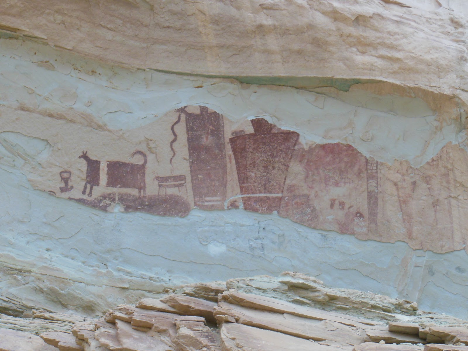
We headed north continuing on Hwy 191 with the next stop near Price, Utah.  We drove in a downpour arriving in town just as the skies cleared.  Price is home to the first Wal-Mart of the trip, so it was time to stock up.  After our re-supply we headed up into the mountains and Nine Mile Canyon.  By the name one would think that the canyon was nine miles long, but it's longer, about 40 miles.  Known as the longest art gallery in the world, the canyon was home to Fremont and Ute Indians and numerous examples of rock art.


We had heard about a ranch where you could camp that is in the canyon.  Nine Mile Ranch is about 25 miles into the canyon and until recently was reached by a dirt road.  With the recent discovery of natural gas in the canyon and surrounding area, the Bill Barrett Corporation, a oil and gas exploration company has spent about 20 million dollars improving and paving the road through the canyon.  With a nice new road, we headed up to Nine Mile Ranch where we were met by Myrna who along with her husband Ben, operate the ranch.  The ranch is a working cattle ranch, but to supplement income, Ben and Myrna have a small campground and a "Bunk and Breakfast".


As I said this was a working cattle ranch, so you had to watch were you stepped.  Lots of evidence of the cows around.  Also horses.


These horses came galloping through the "campground", I think looking for better grazing.  Later I saw Ben, herding them back to their pasture.  As a modern cowboy, Ben used his car to to guide the horses back.  We were the only campers at the ranch and had the run of the place.

The next morning we drove further into the canyon looking for the rock art the canyon is famous for.  Here are some examples:


Continuing on through the canyon one exits into the Unita Basin in Northeastern Utah.  The Unita Basin is experiencing a boom with all the oil and gas exploration.  We drove for miles seeing hundreds of oil wells.


An information kiosk at an overlook explained that most of the wells are 4,000 to 6,000 feet deep and that below the temperature of 110 degrees the oil is the consistency of shoe polish. Because of the depth and the pressure of the earth at that depth, the oil is in a liquid state.  Standard pumping recovers about 10% of the oil, but by injecting water into the deposit through a separate well, 25% of the oil can be recovered. 

After another night at the ranch, we moved about 130 miles north to Vernal.  Nearby is Dinosaur National Monument which straddles Northeastern Utah and Northwestern Colorado.  I can remember a family trip  here in 1958 and what I remember most as a child was obtaining a Dinosaur Hunting Licence.  They still give them out at the Utah Visitor Center near the state line.  Of course the National Park Service in it's desire to be politically correct, does not issue the licences.


We paid a visit to the Bone Quarry, but I managed to leave my camera back in the RV, so I borrowed these photographs from Google.  Pretty interesting and the kids love it.  One is actually allowed to touch some of the bones that are embedded in the hillside.

The next day we drove to Echo Park in a different part of the Monument, this time with the camera.  In this part of the county, lots of areas are called "parks".  There is Castle Park, Island Park, and Echo Park all within the Monument.  Now for those of us from Southern California, when we think of a park, we usually think of a place where gang members hang out.  Up here in this part of the world, "park" has a completely different meaning.  It refers to an area of beauty that sometimes covers a large area.  Hence the desire to visit Echo Park.

When one reads about how to get to Echo Park, the description of the road makes one wonder if it is worth while.  At least after reading the description provided by the Park Service.


Because it had been raining of late, I attempted to find out if the road was passable or not.  Asking several park employees, including rangers, I got the same answer.  No one had an answer, nor did they seem willing to find one.  It seemed as though they were trying to discourage you from going.  We figured we would have to go and find out for ourselves.  Well the road was dry and passable.  The sign says, "no trailers", but river rafters haul trailers up and down the road with their rafts.  As the the advisory against passenger cars, grandpa could drive his Cadillac down this road.  Yes it was a dirt road, steep and narrow in places, but it it's a county road and well maintained for a back country road.   The road descends from the plateau to the canyon bottom, a decent of 2500  feet.

So what gives with the Park Service.  I'm used to my elected official misleading me, but now the Park Service does it too.  It's obvious to me that they are trying to keep people from enjoying their park.  Well despite their best efforts, we enjoyed ourselves in an absolutely beautiful area.

Echo Park is at a bend of the Green River surrounded by towering cliffs.  See for yourself.


THE ROAD
NICE ROAD


MORE NICE ROAD


STEAMBOAT ROCK IN ECHO PARK


THERE'S EVEN A CAMPGROUND

ECHO CAVE IN ECHO PARK


CREW RANCH

The Crew Ranch still exists in the park, but this part of the ranch was sold to the park service in the early 60's
We've been thinking of buying a new RV
This one looks nice

FROM ABOVE

LOOKING DOWN AT THE PARK

Well that about does it for Utah.  We've been traversing the east side of the state for almost a month.  We now continue to follow Hwy 191.  Next up, Wyoming and the Grand Tetons.

Friday, May 10, 2013

SAN RAFAEL SWELL


After a week in Moab, we continue our slow movement northward.  We headed for Goblin Valley State Park which is located out in the middle of nowhere.  Well actually it's located near the San Rafael Swell a geologic formation running in a north/south direction in east central Utah.  The was no room at the state park, so we opted for a dry camp on BLM land nearby.

We had met Don and Dorothy at our camp in Moab and they met up and camped with us at the Swell.  Both retired, Don and Dorothy travel in their Lazy Daze motorhome for 8 months out of the year.  Hailing from Montgomery, Alabama, they talk a little funny.  They write a blog about their travels and you can read it HERE.

First up was a walk up Little Wild Horse Canyon, a narrow slot canyon in the Swell.  In 2009, my friend Gary and I had explored the canyon, but Cathie had missed the opportunity.  A very accessible slot canyon, it gets lots of visitors.  The parking area at the trailhead was packed with cars, so we saw plenty of people.  Still quite a sight with scalloped walls which narrow down to about 2 feet wide in some spots.

 STARTING UP THE SLOT

 CATHIE IN THE SLOT

 NARROW

 SCALLOPS


The next day we had intended on driving and hiking to Horseshoe Canyon in a unit of Canyonlands National Park.  The canyon has some of the best rock art in the world.  Getting there involves 32 miles on a dirt road and a 7 mile round trip hike.  With rain threatening we diced not to chance the road, as when wet it becomes a quagmire.  Instead we explored the area around our camp.


These pictographs were nearby.  The painting in the lower photograph has bullet holes in it.  We also noticed defacing of the rocks in Little Wild Horse Canyon, with idiots scratching their names and other writings in the stone.  WHAT THE HELL IS THE MATTER WITH THESE PEOPLE?


In this photo of our camp if you look closely you can see a cave (a dark spot center right) in the Swell.  We took a hike across the slick rock working our way up to the cave.  Actually it turned out to be two large alcoves side by side.


The alcove on the right was huge with a large hole in it's ceiling.  To give you an idea of it's size  here is a photo of Cathie standing inside.


Even in 1914 Travis was an idiot.  There are peoples names carved all over the rocks.  Also this attempt to fool people looking for rock art.  These drawing were really crude in comparison with the real thing.

LOTS OF FLOWERS


After a day of exploring we were enjoying happy hour with Don and Dorothy when it started raining.  At first just a sprinkle or two.  But then it really started in earnest.  Being camped at the end of a dirt road several hundred yards from the pavement, we decided it was best to move camp before we were stranded in the mud.  We move to a better location with less mud which turned out to be a good idea as it rained off and on all night.

In the morning we said our goodbys to Don and Dorothy.   The were heading to Salt Lake City and we were continuing our trek northward.

SAN RAFAEL SWELL


Saturday, May 04, 2013

MOAB PART TWO

There's something about the area around Moab that keeps us coming back.  We've lost count of the number of times we've been here, has to be at least 7 times.   We are always awe struck by the color of the landscape with it's different shades of reds and browns, it's rock formations and it's towering cliffs.  We also always seem to find some new spots to explore.  The other day we took a bike ride along the Colorado River.  An easy flat ride on a less traveled state highway.  As this is bike country, cars that pass us give us a wide berth.  While enjoying the scenery, I noticed a canyon that we had never noticed before and we decided to check it out after our ride.

No one around, hardly any footprints, a running stream, and 500+ cliffs enclosing a green oasis.  It doesn't get much better than that.


Under a canopy of mature Cottonwood Trees we walked along, sometimes in the small stream.  After about a mile or so, the trees thinned out and the canyon became dry and hot.  The stream had disappeared so we turned around and headed back to the road.  On the way back it appeared that it had snowed as evidenced by the white around the stream and falling of the snow.


SNOW IN THE DESERT
The Cottonwood Trees were shedding their seed  pods, turning the landscape white.

Every time we come to Moab, we hike up to Delicate Arch in Arches National Park.  Not a long hike, about 3 miles round trip.  It is up hill, but usually worth the effort.  This trip we decided to hike up for the sunset.  We tried this once before on a previous visit, but our hopes a some good photograph were dashed by a huge thunderstorm that hit just after we reached the arch.  Here is a photo taken at the time of the approaching storm.


You can read the blog entry about this storm by clicking HERE.

On this trip we were more successful in getting some photos of the arch at sunset.  Of course we weren't the only ones who  had the same idea.


Everyone wants a photo of themselves under the arch, but a lot of people hike up here to get a sunset photo of the arch, without all the people.  Finally someone yelled, "we came here to photograph the arch, not you".  The people got the message, and the cameras clicked.

Two of my photos


ON THE TRAIL BACK

Cathie and I both agreed that now that we had seen the arch at sunset, we didn't have to do it again.  Just too many people.

We managed one more hike in Arches before we head out of Moab.  We paid a visit to Tower Arch, in a more remote part of the park.  We saw a few people, but nothing like the more popular areas.

TOWER ARCH

Tomorrow we leave Moab up the road just about 100 miles.   We found out that there are some places nearby that we haven't seen before.  We'll be off the grid, no Internet or phone for 4 or 5 days.  We'll catch up when we find civilization.