Tuesday, May 28, 2013

AND WE CONTINUE


After a brief pause in Great Falls, Montana to catch on a new nephew, the next stop on the agenda was Libby Montana, the City of Eagles.  Located in the northwest part of the state, the stop at Libby was because that's where Cathie's brother Rod lives.  We laid low in Libby, not doing a whole lot other than eating and keeping dry.  Rod and his wife Mary  have a beautiful home on 8 plus acres with a view of the  Cabinet Mountains that can't be beat.


 We did manage one short excursion between rain showers to Kootenai Falls on the Kootenai River.  Being springtime, the rivers are at capacity with snow melt which added to the thunderous roar of the falls.  What they lack in height is made up by the shear volume of water in the cascades.  Nearby is a suspension bridge and moves about as you walk across it.  Not for the faint of heart.


After six days in Libby, moss started growing on us so we figured it was time to move on.  We made a left turn of sorts at Libby and started heading west.  We made an overnight stop in Kettle Falls, Washington to see my brother Joel.  Tina made sure that we had plenty to eat with a feast of BBQ ribs for dinner and french toast the following morning.   By late morning we got underway and by mid-afternoon we landed in Winthrop, Washington.  Winthrop is a very busy tourist attraction consisting of old western style buildings that house shops and restaurants that cater to folks who visit here.  Arriving on Memorial Day we found ourselves creeping along for about 30 minutes trying to get through the one stop sign in the middle of town.


We managed to make it through town and settled in at  Pine Near RV Park, a really nice RV park just off the main drag.  The center of town didn't excite me much, but the area around here is beautiful.  Located on the eastern side of the Northern Cascade Mountains in the Methow Valley, the hiking opportunities abound.  It is also said that being on the eastern side of the Cascades it is dryer than on the western side.  So that means it still rains, just not as much as the other side of the mountains.  We decided to try out our wet weather gear and took a nice 6 mile hike along the Methow River.  For the most part we stayed dry and enjoyed our walk in the rain.  Even with the rain, we have already started talking about coming back next year here.


Tomorrow we will cross over the Cascades and head for the coast.  Maybe we'll get lucky and the rain will stop.   Rrrrright, it's not called Fungus Corners for nothing.

Friday, May 17, 2013

IN THE GRAND TETONS WITH THE ANIMALS


I just can't get over how beautiful this place is.  Those lofty peaks towering over the Snake River Valley  as it cuts through this part of Wyoming.  We paid for 3 nights, then added an additional night, and then another.  I even checked out the possibility of a seasonal job as a volunteer for a future visit.  We would have stayed longer, but Cathie has two new nephews waiting for her to hold in Montana, so we must continue northward.  (Why do you think we came on this trip).

We had great weather in Grand Teton National Park, until the last day when the rain began.  It started while on a hike, but later in the day in came in earnest raining through the night.


We've been here before, but the last time we cut the visit short because I had injured my shoulder kayaking.  I had gone to the hospital in Jackson and was told to get home to see my own doctor, so that's what we did.  This time we stayed a little longer.  May is a great time to visit in some regards, no crowds and plants are just starting to turn green.  The downside is that much is still closed.  All the lodges and most of the campgrounds are closed, but I consider that a good thing.  Most of the hiking trails at higher elevations are still covered with snow and some of the lower elevation trails are partially covered, a bad thing.  We stuck to hikes closer to the valley floor around some of the lakes.  Because it's early in the season, we saw few hikers.


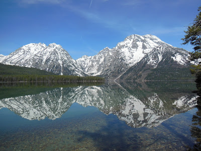
LEIGH LAKE

Our first hike along the shore of Leigh Lake was along pretty level ground.  We did have some snow to contend with and it appeared from the tracks in the snow that only a few people had been on the trail so far this season.  That didn't mean that some of the local residents hadn't walked on the same path.  They warn you about bears just about everywhere, but although we saw lots of animals, we never saw a bear.  But pretty fresh tracks on the same trail as you, tend to make you pay attention.


LEIGH LAKE REFLECTION

Our second choice for a hike was to be Two Ocean Lake in the north end of the park, but it was not to be.  We arrived to find the road to the trailhead was closed due to snow, so we ending up taking a driving tour around the park.  We were going to ride bikes as the park and the City of Jackson have some really nice separate bike routes.  But we got lazy.  Next day another hike to another lake.  Actually two lakes, Bradly and Taggart and more beautiful country.

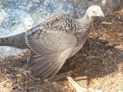
We had to traverse some snow at the higher elevation and we were postholeing to mid thigh.  Cathie noticed some movement out of the corner of her eye and discovered that we were being followed by this grouse.


She followed us for quite some time and when we stopped for a break, so did the grouse.  She let us get really close and we probably would have been able to touch her.


For our last hike we decided to climb Blacktail Butte, which we could see from our camp.  Not one of the designated trails on the parks list, still there is trail of sorts which follows a ridge line, climbing to 1100 feet above the valley.  The butte rises from the middle of the valley and is said to be home to most of the animals that populate the park.  Of course this worried Cathie as she believes there is a bear out there that wants her.  When we reached the summit the wind and rain started, so I suggested that we get inside the tree line until it passed.  As we entered the trees, I kidded Cathie, saying "this is where we'll see a bear".  We walked about 50 yards into the trees when we were startled, not by a bear, but a moose.  It had been laying down under the tree we were headed for, but was nice enough to run off deeper into the forest.

Speaking of animals of the park, we did manage to see many of them.


PRONGHORN

BISON


A LARGE FOX


LOTS OF GEESE 

FOUR MOOSE IN THIS AREA NEAR CAMP

MARMOT

ELK

BIG HORN SHEEP (NOT THE HORSES)

GROUSE


MOOSE RESTING IN CAMPGROUND


The only one we missed was the bear.  Maybe next time.

After scampering down Blacktail Butte we managed to dodge most of the rain, but once back in camp, the rain stayed with us into the night and the next day. 


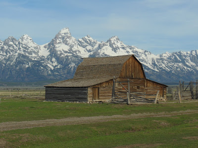
This barn and the one earlier in this posting is some of what's left of the town of Grovont, now know as Mormon Row.  There are a few other buildings including several homes all, with the exception of one, is no longer occupied.  The barns were part of homesteads from the early 1900's.  In the mid 1900's the settlers' land was acquired to expand the National Park.

JUST OUTSIDE THE PARK, RED ROCK RANCH


We leave Grand Teton in the rain continuing northward.  We are now in a RV park in Ennis, Montana, listening to the rain beat on the roof.  Rain is forecast for the next several days, so we'll do our best to stay dry.


Sunday, May 12, 2013

AT THE RANCH AND DINOSAUR LAND

We headed north continuing on Hwy 191 with the next stop near Price, Utah.  We drove in a downpour arriving in town just as the skies cleared.  Price is home to the first Wal-Mart of the trip, so it was time to stock up.  After our re-supply we headed up into the mountains and Nine Mile Canyon.  By the name one would think that the canyon was nine miles long, but it's longer, about 40 miles.  Known as the longest art gallery in the world, the canyon was home to Fremont and Ute Indians and numerous examples of rock art.


We had heard about a ranch where you could camp that is in the canyon.  Nine Mile Ranch is about 25 miles into the canyon and until recently was reached by a dirt road.  With the recent discovery of natural gas in the canyon and surrounding area, the Bill Barrett Corporation, a oil and gas exploration company has spent about 20 million dollars improving and paving the road through the canyon.  With a nice new road, we headed up to Nine Mile Ranch where we were met by Myrna who along with her husband Ben, operate the ranch.  The ranch is a working cattle ranch, but to supplement income, Ben and Myrna have a small campground and a "Bunk and Breakfast".


As I said this was a working cattle ranch, so you had to watch were you stepped.  Lots of evidence of the cows around.  Also horses.


These horses came galloping through the "campground", I think looking for better grazing.  Later I saw Ben, herding them back to their pasture.  As a modern cowboy, Ben used his car to to guide the horses back.  We were the only campers at the ranch and had the run of the place.

The next morning we drove further into the canyon looking for the rock art the canyon is famous for.  Here are some examples:


Continuing on through the canyon one exits into the Unita Basin in Northeastern Utah.  The Unita Basin is experiencing a boom with all the oil and gas exploration.  We drove for miles seeing hundreds of oil wells.


An information kiosk at an overlook explained that most of the wells are 4,000 to 6,000 feet deep and that below the temperature of 110 degrees the oil is the consistency of shoe polish. Because of the depth and the pressure of the earth at that depth, the oil is in a liquid state.  Standard pumping recovers about 10% of the oil, but by injecting water into the deposit through a separate well, 25% of the oil can be recovered. 

After another night at the ranch, we moved about 130 miles north to Vernal.  Nearby is Dinosaur National Monument which straddles Northeastern Utah and Northwestern Colorado.  I can remember a family trip  here in 1958 and what I remember most as a child was obtaining a Dinosaur Hunting Licence.  They still give them out at the Utah Visitor Center near the state line.  Of course the National Park Service in it's desire to be politically correct, does not issue the licences.


We paid a visit to the Bone Quarry, but I managed to leave my camera back in the RV, so I borrowed these photographs from Google.  Pretty interesting and the kids love it.  One is actually allowed to touch some of the bones that are embedded in the hillside.

The next day we drove to Echo Park in a different part of the Monument, this time with the camera.  In this part of the county, lots of areas are called "parks".  There is Castle Park, Island Park, and Echo Park all within the Monument.  Now for those of us from Southern California, when we think of a park, we usually think of a place where gang members hang out.  Up here in this part of the world, "park" has a completely different meaning.  It refers to an area of beauty that sometimes covers a large area.  Hence the desire to visit Echo Park.

When one reads about how to get to Echo Park, the description of the road makes one wonder if it is worth while.  At least after reading the description provided by the Park Service.


Because it had been raining of late, I attempted to find out if the road was passable or not.  Asking several park employees, including rangers, I got the same answer.  No one had an answer, nor did they seem willing to find one.  It seemed as though they were trying to discourage you from going.  We figured we would have to go and find out for ourselves.  Well the road was dry and passable.  The sign says, "no trailers", but river rafters haul trailers up and down the road with their rafts.  As the the advisory against passenger cars, grandpa could drive his Cadillac down this road.  Yes it was a dirt road, steep and narrow in places, but it it's a county road and well maintained for a back country road.   The road descends from the plateau to the canyon bottom, a decent of 2500  feet.

So what gives with the Park Service.  I'm used to my elected official misleading me, but now the Park Service does it too.  It's obvious to me that they are trying to keep people from enjoying their park.  Well despite their best efforts, we enjoyed ourselves in an absolutely beautiful area.

Echo Park is at a bend of the Green River surrounded by towering cliffs.  See for yourself.


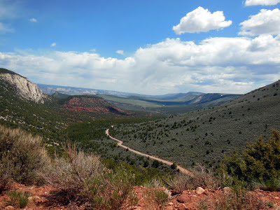
THE ROAD
NICE ROAD


MORE NICE ROAD


STEAMBOAT ROCK IN ECHO PARK


THERE'S EVEN A CAMPGROUND

ECHO CAVE IN ECHO PARK


CREW RANCH

The Crew Ranch still exists in the park, but this part of the ranch was sold to the park service in the early 60's
We've been thinking of buying a new RV
This one looks nice

FROM ABOVE

LOOKING DOWN AT THE PARK

Well that about does it for Utah.  We've been traversing the east side of the state for almost a month.  We now continue to follow Hwy 191.  Next up, Wyoming and the Grand Tetons.