Friday, December 02, 2011

WHALE PEAK (5348 Ft)


It's been about 20 years since I climbed up Whale Peak out in the Borrego Desert and I figured it was about time to do it again.  My friend Gary, who has been hankering to go on a hike, said he would go with me.  So a couple of weeks ago, I picked him up at 0 dark thirty and we drove out to the desert.  The best way to climb this mountain is to drive via a 4 wheel drive road to the 4000 foot level before starting out on foot.  The road to the trail head isn't too bad except for one particular spot where high clearance is definitely required.  The old 4-Runner handled it well, cutting off about 2 additional miles of hiking if we hadden't gotten over the rough spot.

The first part of the hike is pretty straight forward and pretty much straight up.  Well not exactly, but none the less uphill via a slot with lots of boulders.

 LOOKING DOWN THE SLOT

Twenty years ago the route to the summit was cross country with one doing their own navigation.  Back then I along with friends failed on our first attempt, having taken the wrong turn.  The second attempt was successful, but it too required some route finding skills.  Anyway off we went on the route I remembered, or at least though I remembered.

 GARY COMING UP BEHIND

Everything was going along just fine, when I heard Gary make an odd noise behind me.  When I turned to look I found Gary rolling down the hill though some of the ever present Cholla Cactus.  Gary's head stopped him from rolling down too far when it met with a non movable rock.


After figuring out that Gary was ok with no broken bones, he said that he had enough of my route finding skills, so after just 3/4 of a mile we turned around and headed back. (Actually Gary was kinda bruised up)  We didn't know it at the time, but we were a little bit off track.

Twenty years is a long time, but I thought I knew where we were going. If you take a look at the Google Earth map, the little white dots are the route we selected.  The purple line is the route we should have taken, but I didn't enter the correct route in the GPS until after I got home. Duh!

Anyway the mountain was still there and I still wanted to Climb it.  So this time I enlisted Cathie, who said she was game to give it a go.  She had climbed it with me on the previous summit and figured I could find the way again, especially now that I had the  route in the GPS.

It was cold and clear on the way up with patches of snow in the shaded areas.  No wind to speak of, so it was a pleasant hike.  We got a little off track by trying to avoid some steep sections by side hilling.  When we got to the top of one ridge, we looked down the other side and noticed a really nice looking trail crossing the high valley below us.  Now 20 years ago, we never came across any trail nor had we heard that there was one.  But now 20 years later there it was.  So we headed down to the trail and followed it all the way to the summit.  With just one steep section just below the summit, the rest of the hike to the top was pretty easy.

 CATHIE LOOKING BACK

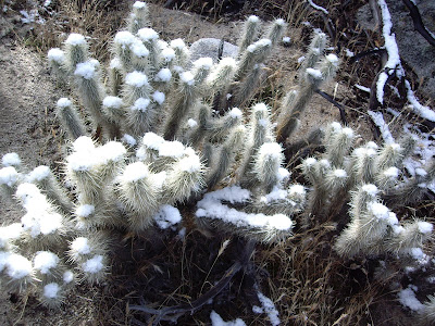
 SNOW ON THE CHOLLA
 WOW! A TRAIL

 ALMOST THERE

 CATHIE IN THE STEEP SECTION

ON THE TOP

 SUMMIT REGISTER

 SHELTER

 THAT'S BORREGO SPRINGS OUT THERE

 ON THE WAY DOWN WITH THE TRAIL BELOW

After about 45 minutes on the summit, we headed back down.  This time we followed the trail which made it a piece of cake finding ouR way.  Next time we'll follow the trail from the get go.  Think Gary will try again?  Only if he gets to lead.
 
 WHALE PEAK


Thursday, November 10, 2011

WINDING DOWN

 BIG BEND SUNRISE

Before leaving Big Bend National Park we took a short hike up Santa Elena Canyon.  The Rio Grande flows through this narrow canyon and is very popular with river runners when the water level is up in the spring and summer.  The trail up the canyon only goes for about a mile, before the river stretches between the canyon walls preventing further exploration.


 SANTA ELENA CANYON


 JEFF DAVIS COUNTY COURTHOUSE

One thing we noticed in our travels in the Midwest and especially in Texas is that many rural counties have very large and imposing courthouses.  Most of these buildings were build in the early 1900's or before.  Jeff Davis County only has a population of 2300 souls but the courthouse looks like it could be from a much larger county.  About 1000 of those live in the county seat, Fort Davis.


 TEXAS BACK ROAD

The city of Fort Davis takes it's name from, you guessed it, Fort Davis  a National Historic Site.  Fort Davis was founded in 1854 and was named for then Jefferson Davis, the Secretary of War.  During the Civil War the fort was abandoned by the Union Army, but reoccupied after the Civil War in 1867.  By that time travel on the San Antonio-El Paso Road increased and so did raiding by Comanches and Apaches, prompting the Army in re-establishing Fort Davis.  Today many of the original buildings have been restored and furnished to the period when Fort Davis was an active Fort. 


 OFFICER QUARTERS

 ENLISTED MENS BARRACKS

 CHANGING COLORS

The Cottonwoods in West Texas are turning gold and for us that is a signal to head for home.  We've been on the road  just shy of 3 months and it was time to head home.  Besides, Cathie can hardly wait to see the grandkids.  As we crossed from Arizona into California Cathie said to me that next time she would be willing to stay gone for four months.  I guess I better start planning.

GOOD TO BE HOME

This morning when I got up, the first morning after getting home, this is what greeted me.

Friday, November 04, 2011

IN THE MIDDLE OF NOWHERE - WEST TEXAS


In the middle of nowhere really describes this part of Texas.  Getting here requires driving about 100 miles south of US Highway 90 and once here you're up against Mexico and can't go any further.  What it lacks in civilization is made up in its beauty and remoteness.  We stayed in the National Park campground at Rio Grande Village, not really a village, but a small store and gas station along with a ranger station and housing for some of the national park staff.  The Rio Grande is not really very Garnde at this time of the year.  You would have trouble floating down it in a inner tube it is so shallow in places, but in the spring local outfitters run river trips through some of the deep canyons created by the river. 


AMMONITE

On a hike we took we came across this Ammonite right in the middle of the trail.  Because it's part of a much larger boulder it's still there and not in someones yard.


We also took a hike in the Chiso Mountains up Lost Mine Trail.  Legend has it that Spanish explorers found a vein of silver around here and enslaved local people to mine it.  According to the legend, the workers eventually rebelled, killed their enslavers, then sealed the mine entrance to prevent further exploitation.  We didn't find it, so the legend remains intact.  The view at the end of the trail, although spectacular, we marred by the constant haze that is usually present in Big Bend.  It's really smog from cities in the east.

Just west of the Park is what's left of the mining town of  Terlingua.   People still live here, but mostly it's been abandoned.  In it's heyday in the early 1900's Terlingua had a population of over 2000, but today there is less than 300.  That is except on the weekend we were there when the population reached upwards of 10,000 chiliheads.  Each year on the first weekend in November, the Chili Appreciation Society International holds its annual  Terlingua International Chili Championship.  Not only do they have chili cookoff, but also BBQ competitions.  We figured to go and see what's up, but when we drove up to the entrance they wanted $30 each for the privilege of entering into the contest grounds.  I asked what we do we get for $30?  We were to we can walk around the grounds and watch all the crazies and drunks.  We don't get to sample any of the chili or BBQ, but if we like we can buy food and drink at an exorbitant cost.  We knew the thing about the drunks was true because just outside the entrance to the cookoff grounds on the state highway, the Texas State Troopers had set up sobriety check points in both directions.  We decided to pass.


The Terlingua Trading Company was known as the Chisos Mining Company Store and sold everything from food to farm equipment and prom dresses to cars.  It housed the mine offices, Post Office and the only telephone.  It is still one of the largest adobe building in Texas.


The Perry School, named after the mine owner, was the largest of 3 schools in the region.  Started as a tent with one teacher and grew to a 5 room building with 4 teachers, a principal and 80 children.

SAINT AGNUS CHURCH 


BROKEN WINDMILL

Tomorrow we continue our exploration of Big Bend Country before heading north for a stop in the Davis Mountains.  From there we will head home after being on the road for 3 months.  To be continued........

Sunday, October 30, 2011

TEXAS

After a few days in Dallas and since we couldn’t get tickets to the World Series we decided to head south to the beach? Having never been to Padre Island we wanted to see it. We planned to stay at the National Seashore campground and talk long walks on the secluded beach. We got an early start for the 425 drive. We were a little concerned about getting a spot in the campground because there have been lots of snowbirds heading south.


After passing through Corpus Christi, we crossed the causeway onto the island. I thought it was somewhat strange that there wasn’t any traffic, nor did we see anyone in an RV. As we drove the approach road to the entrance to the National Seashore, a distance of about 8 miles, we saw no other cars. Very strange. When we pulled up to the entrance station the ranger on duty opened the window as I handed him my senior pass. As I held it out for him to see he asked in a sort of condescending voice, “What to you have there?” I told him it was my senior pass and we were hoping that there was still some room in the campground. “Are you sure you want to go there?” he asked with raised eyebrows. I said, “We haven't driven 425 miles in hopes of finding mountains.” He then said that we could have the whole campground to ourselves as there was no one there. He explained that there was a red tide. “I guess we can’t go swimming then?’’ About this time in our conversation I noticed that my eyes were burning and I could feel a tingling on my tongue. Then I started coughing. He responded by telling us all about Red Tide.

Red tide here in Texas causes all kinds of things to happen. Coughing, burning in the eyes, tingling of the tongue and the inside of the mouth, and if you make skin contact with the tide, rash. The ranger said we were welcome to stay if we wanted to experience all these things but suggested it was best if we went inland or perhaps to Galveston. We ended up in an RV park in town not anywhere near the beach.

While in Corpus Christi I toured the USS Lexington, a World War II aircraft carrier. Smaller than the USS Midway in San Diego where I volunteer, but much the same. The Lexington has more displays, but they don’t have an audio guide like the Midway. Lots of information about different sea battles in WWII with lots of artifacts.


Well, since we couldn’t go to the beach, we headed north to San Antonio. We stopped for lunch at Texas Pride BBQ another place featured on Triple “D”. I heard tell that Texas is famous for its brisket and smoked meats so we just had to find out for ourselves.  Located in an old 1040's gas station, it is truly out in the middle of no where.  You wait your turn at the counter and when it’s your turn and place your order, the meat is sliced off the brisket or the ribs off the rack and wrapped in butcher paper. It is then place in a plastic soda bottle case along with the sides you ordered. You then carry your purchase to the dining room filled with picnic tables where you unwrap your food and eat it right off the butcher paper. We topped it all off with peach cobbler that was really good. The BBQ wasn’t too bad either.


We stayed outside of San Antonio Canyon Lake. Another very nice campground operated by the Army Corp of Engineers. This area is what they call “Hill Country”. It’s very dry due to the past summers heat and drought causing an extreme fire hazard. They won’t even let you use a gas BBQ or camp strove in the campground.

HAPPY HOUR


On our first full day here, we headed into the city and went to the The Alamo and the River Walk. Everyone knows something about the Alamo and those who died there. Today it is considered a shrine to those who died there. Only a small part of the original buildings exist today. The assault by General Antonio Lopez de Santa Anna’s army in 1836 is the most important part of the Alamo’s history, but its history goes back much further. In 1724, construction of the Alamo began. Originally named Mission San Antonio de Valero, the Alamo served as home to missionaries and their Indian converts for nearly seventy years. In the early 1800’s the Spanish military stationed a cavalry unit at the Alamo. The first hospital in Texas was established in the Alamo. In December 1835 the Alamo was attacked by Texan Revolutionaries and taken from the Mexican Army.


On March 6, 1836 Santa Anna began his assault before daybreak. Cannon and small arms fire from inside the Alamo beat back several attacks. Regrouping, the Mexicans scaled the walls and rushed into the compound. Once inside, they turned captured cannon on the barracks and church, blasting open the barricaded doors. The fighting continued until the defenders were overwhelmed. By sunrise the battle had ended and Santa Anna entered the Alamo.


San Antonio is also famous from its river walk along the San Antonio River. Below the street level in the downtown, its banks are lined with restaurants and shops. Walkways on both sides of the river allow you stroll along the shaded path or if you prefer you can take the water taxi. Really beautiful in the daytime, must be something at night with all the trees lit up.

Since we were in Hill Country we paid a visit to the LBJ Ranch. Yes, that ranch. After the death of Lady Bird Johnson in 2007, the ranch was deeded to the American People and is overseen by the National Park Service. You can tour the ranch in your car with an accompanying CD. Then for $2 you can go on a short tour of the Texas While House.

The ranch is still a working ranch, growing grain and hay for the Hereford cattle being raised there. You are free to walk around the outside of the house. On a rise overlooking the Pedernales River the house is surrounded by huge mature oaks which shade the front of the house. Johnson sometimes held cabinet meetings under the trees in the front yard. I was easy to see why as President, LBJ preferred being at his ranch in Texas over being at the White House in Washington.


This is one of LBS's neighbors and now a Texas State Park.  It is a demonstration farm where volunteers operate the farm as it was in the early 1900's.  They milk the cows each morning, make butter and cheese, butcher the hogs, smoke the bacon with no modern conveniences.  Very interesting tour given by those working there.

JOHNSON CITY COURTHOUSE

HILL COUNTRY WINDMILL


Saturday, October 22, 2011

Dallas/Fort Worth


Here we are in the Great State of Texas where, according to native Texans, everything is bigger.  So to see if this is true we went to the State Fair of Texas, which according to the hype is the biggest state fair in the country.  We took the train into Dallas and transferred to the trolley for a stress free ride to the fair.  We decided to go on Thursday as it was senior day, so we got to bypass the $15 admission and got in for free.  So saving $30 is pretty big.  To purchase just about everything at the fair you have to purchase tickets and then redeem them with the vendor of your choice.  We used the $30 we saved and spent it on tickets.  Being senior day the movement around the fair was pretty slow, with the exception of those in their motorized chairs.  Lots of big excitement dodging them folks.


This is Big Tex, who greets you at the fair.  He speaks, but I couldn't understand what he was saying, perhaps it's his accent.  You know how those Texans talk.  He is big though.


They've got an Aremotor Windmill at the fair, but it's no bigger than the one in my front yard.  Nice paint job though.


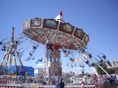
There are some pretty big rides at the fair.  I can't ride most of them because the of the centrifugal force.  On a ride where everything in your stomach is pushed down as it goes around and at the end of the ride it's the big heave-oh, if you get my drift.  They claim that the Farris wheel at the fair is the biggest in the country.  We bypassed the rides.


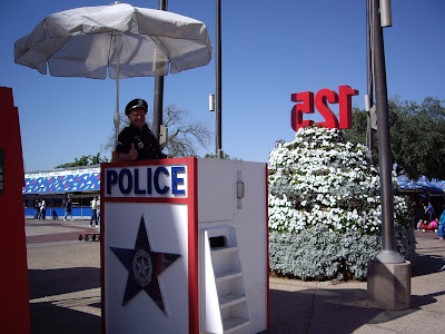
There is a big presence of the Dallas Police at the fair.  Many are posted in theses elevated boxes.

BIG INDOOR FOOD COURT

Food is really big at the fair.  In fact there are more places to buy food at the Texas State Fair than in the greater Dallas - Fort Worth area.  They have the biggest offering of fried items.  Besides the normal French fries and fried chicken, there is fried bubble gum, cookie dough, peanut butter and jelly sandwiches, Snicker Bars, smores, beer, wine, margaritas, coke, pralines, latte, ice cream, banana splits, chicken fried bacon, butter, peaches and cream, Frito pie, pumpkin pie, pineapple upside down cake, salsa and Han's Fired Kraut Ball.  So Texas is biggest in the fried food category and in the accompanying clogged artery category.  Tried the deep fried cookie dough.  Hard to get it down because it's so rich.  Did leave a big lump in my belly.

Actually we weren't very impressed with the fair.  A big area for the car show, which was just a bunch of new cars from various manufactures.  A pretty big area for vendors selling pots and pan and the like.  We didn't hit the animal area because of the big smell.  There was no industrial arts, photographs, and crafts which at the Del Mar Fair are judged and awarded ribbons.  The Cotton Bowl is on the fair grounds which takes up a pretty big area.  All in all a pretty big disappointment.


The next day we went to the Fort Worth Stockyards where we saw some big cows with big horns.  For the drovers heading longhorn cattle up the Chisholm Trail to the railheads, Fort Worth was the last major stop for rest and supplies. Beyond Fort Worth they would have to deal with crossing the Red River into Indian Territory. Between 1866 and 1890 more than four million head of cattle were trailed through Fort Worth which was soon known as “Cowtown” and had its own disreputable entertainment district several blocks south of the Courthouse area that was known all over the West as Hell’s Half Acre.

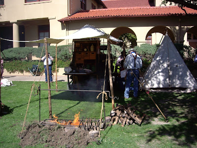
We arrived in time to watch the cattle drive which occurs twice a day.  We happened to be there when they were having a Cowboy Gathering.  We watched as 20 chuckwagons were paraded down the street.  They then set up in front of the Live Stock Exchange for their annual cookoff.  All the food will be prepared over wood fires and in cast iron dutch ovens.


THE POOPER SCOUPERS


In the evening we met friends Nick and Dianna at Uncle Bucks Steakhouse and Brewery in Grapevine for dinner.  Uncle Buck is connected to Outdoor World part of the Bass Pro Shop Chain of really big sporting goods store.  Of course the've got stores all over the states, not just in Texas.  We had a great dinner and visit, catching up on the latest goings on in both our families.

Next up on this adventure will continue in Texas.  We're heading south to Corpus Christi and Padre Island, which I understand has a really big beach.