Sunday, August 28, 2011

CLIMBING MY MOUNTAIN


MOUNT DANA (13,045 FT)
(for my European friends: 3976 Meters)

It was with some apprehension that I attempted to climb Mt. Dana after having to turn around the last time. In 2009 when I attempted the climb, I became dizzy and actually felt like I was going to fall off the mountain. It also doesn’t help that I don’t like high places with exposure, like the edge of a cliff. Having spent the three previous days hiking at high elevation, I figured it was now or never.

The trail up Dana climbs 3,000 feet in 3 miles, so it’s pretty steep. It’s not a designated or marked trail, but due to the fact that you can climb a peak that is over 13,000 feet in such a short distance, it attracts lots of climbers. The trail made by all these people is well worn for most of the way up. In the last 800 to 1000 feet the trail becomes less defined as people pick the way that looks best to them. This latter part of the ascent is mostly picking your way up through rocks of varying sizes.

I started out at 6:30 with the temperature in the low 40’s. Last time it was in the 20’s when I started out with some wind. I was hoping for no wind this time because it was so cold with my last attempt. This first half mile or so winds its way through trees, past several small lakes and is pretty level. Then the trail starts its climb in earnest passing by lots of pretty flowers. About halfway up at an elevation of 11,500 feet, the trail levels out as it crosses a high plateau. I rested here for about 15 or 20 minutes hoping to better acclimate myself to the elevation.

FLOWERS ON THE WAY UP
LOOKING DOWN ON THE PLATEAU

After the plateau is where the trail becomes less defined and you begin picking your way up through the boulder field all the way to the top. It was here, about 400 feet or so from the summit, where I stopped last time. This time I stopped and rested a little bit every so often. I felt really good with no light headedness or dizziness.

BOULDER FIELD

I reached the summit after 3 hours and 40 minutes, not too bad for an old man. Once on top I did get some light headedness. With the east side of the mountain a shear cliff down over 1,000 feet, I just sat down so I wouldn’t feel like I was falling. I stayed at the summit for about 40 minutes, taking in the fantastic views and searching for the summit register. It was no where to be found which was disappointing as I sort of wanted to sign in and claim my mountain. My only company during my stay on top was a whole bunch of bees or wasps. There were buzzing around everywhere, but I never saw them land. What they’re doing on top of Mt. Dana beats me.

LOOKING SOUTH FROM THE SUMMIT
SUMMIT SHELTER
MONO LAKE

Here's a 360 degree video


After a while I noticed other hikers crossing the lower plateau, so figuring that it would soon be crowded on top, I headed back down.

LOOKING BACK
At the end of the day, a meal at the Whoa Nellie Deli in Lee Vining was in order and well deserved.  Cathie helped eating this pizza, which by the way provided us with lunch for the next two days.

BBQ CHICKEN PIZZA
Now that I have completed this entry on my bucket list, I’ll have to find other peaks to climb. Then again, I didn’t get to sign the summit register, so I just might have to go back.


Friday, August 26, 2011

THE FIRST STOP

We’ve been five days in a forest service campground just outside of Lee Vining. Now that I’m old enough for a National Park Senior Pass, these campgrounds are half price. The pass cost all of $10 and is good until such time as you die, or can no longer navigate your way to a National Park. With Yosemite just up the hill from where we’re camped, I take great pleasure in flaunting my senior pass at the entrance station rather than handing over twenty bucks.

The weather has been great, so each day we head up the hill for a hike in the Yosemite high county. First up, Gaylor lakes. The trail begins just inside the east entrance of the park and climbs steeply up the hill to a saddle overlooking the Gaylor Lakes Basin. The area around the lakes is pretty much devoid of trees with the lakes surrounded by vast meadows. Once in the basin, hiking becomes less strenuous as the inclines are slight. We walked up to one ridge to the Great Sierra Mine, long ago abandoned. There are the ruins of several stone cabins and some mine shafts. The views are spectacular. On the way back, I took a detour to climb Gaylor Peak (11,000) while Cathie waited below.

GAYLOR LAKE

STONE CABIN

VIEW FROM GAYLOR PEAK
The next day we headed out on an 8 miles jaunt to Mono Pass. Mostly hiking through forest to the pass at 10,600 feet which is situated in a high alpine meadow.

MONO PASS

The following day we decided to try for Mt Hoffman (10,850). Halfway up is May Lake, where there is one of the High Sierra Camps (web site) that are in Yosemite. You can hike to a series of camps, spending the night in a bunk in one of the tents that are heated with a wood burning stove. Dinner and breakfast is served in the mess hall tent. All this for a price of course.

MAY LAKE

We continued up the trail which became pretty steep. As the elevation increased, our speed decreased. Pretty much up hill the entire way. The description of the climb that I read before deciding to tackle Mt. Hoffman said it was a 5 out of 10 to the lake and a couple of notches more to the top of the mountain. Well, that’s what we experienced up until we reached a point about 200 vertical feet below the summit. The description made no mention of the rock climbing required to reach the summit. We don’t do rock climbing. Also, as you may or may not know, but I do not like heights and basically have to be on my hands and knees if there is any exposure to falling from high places. So we failed to make it to the top but we did get to experience natures stairmaster for the 1-1/2 miles from May Lake.

MT HOFFMAN

So, why all this hiking and climbing at high elevations? If you are a follower of this blog, you may recall my attempt of Mt Dana in the fall of 2009. In that attempt I failed to reach the summit due to my getting really dizzy just shy of the summit. In an effort to be better acclimated, the past three days were spent in preparation. You’ll just have to wait for the next installment to see if all this effort pays off.

I suppose there are many dangers one faces while hiking in the back country. You might get lost, fall and break something, get caught in a storm, or perhaps attacked by a wild animal. But in reality, the most dangerous obstacle one faces, at least while hiking in the eastern side of Yosemite, is the drive to the trailhead.

Each morning we would drive from our campsite near Lee Vining up the Tioga Road to the summit and the entrance to the park. In days of old, the road it self was dangerous. I can recall with some clarity a family trip to Yosemite in 1962. Back then my father’s vehicle of choice was a 1957 VW bus. The bus was capable of speeds upwards of 55 MPH, providing we were going down hill with the wind behind us. Climbing up the Tioga Pass was indeed a test of German engineering. The road back then was narrow, one lane in places, steep, and included numerous hairpin turns. So steep was the grade that the only gear low enough in the VW gearbox to maintain momentum up hill was reverse. So we backed up the mountain, at least some of the way.

Today Tioga Pass is a superhighway in comparison. The danger is not in the road it’s self, but the idiots who drive it. Oh sure, it’s still pretty steep and if one were to drive off the edge into Lee Vining Canyon, you in all probability would not survive, but there are no longer any hairpin turns or one lane sections. The problem is the views. They are spectacular. So it goes something like this:

The Jones from Iowa, where there are no hills of any consequence, having driven halfway across the county, finally arrive at the approach to Yosemite. Or perhaps they’re leaving and heading down the grade. In any event, they have never seen anything like this before and as luck would have it, I am usually in the vehicle behind them. As Henry white knuckles it along the road at his chosen speed of 7 MPH, Opal in the passenger seat has the camera ready to record this momentous occasion for the folks back home. At some predetermined time only known to Opal and when the view becomes the most spectacular she instructs Henry to STOP. And stop he does, right in the middle of the road. Pulling over in one of the view points would get one to close to the edge for Henry’s comfort so the road seems like the best option. It doesn’t matter that I, along with a gazillion other sensible drivers are behind him. So out steps Opal, who snaps several photographs in all directions, including one of all the vehicles which are now backed up to the bottom of the hill.

Then there are those drivers who when looking at some site off to the left, lose their concentration and turn the steering wheel in the direction they are looking. This usually means crossing over the center line into the oncoming lane, where as luck would have it, I JUST HAPPEN TO BE. I wonder what Henry and Opals’ friends will think when they see the picture of the pissed off driver of a Ford truck giving them the one finger salute. So you see, once at the trailhead parking lot, the safe part of the day begins.


Wednesday, August 17, 2011

HERE WE GO AGAIN

In a few days we'll be heading out on another RV trip, this time to the middle.  The middle of the country that is, somewhere we've passed through, but spent little time.  The plan goes something like this....first to the Eastern Sierras for a week or so to do some hiking.  After that we'll make a right turn and head east across Nevada and Utah towards Colorado.  We've been to the southern part of the state on several occasions, but never Central or Northern Colorado.  Next up will be the Mid-West, Kansas, Nebraska, South Dakota, Iowa and Missouri, before turning south towards Mississippi and Arkansas.  We'll then turn towards the West and visit Oklahoma and Texas before heading home.

Some have asked, why in the world would we want to go out in the plains?  It's just a big flat nothing.  Well, we don't think so.  We'll travel on the secondary roads as much as possible and avoid the interstates.  It's my guess we'll find plenty of interesting places.  We should be home sometime in November, unless of course we run out of money before then.  As is our custom, we reserve the right to change our plans at anytime, staying longer in places we like and leaving those we don't.  I'll be blogging along the way, so say tuned.

Thursday, August 04, 2011

BACK TO THE SIERRAS

After being the the Eastern Sierras a couple of weeks ago, I got the bug for some more hiking.  This time Cathie didn't catch the same bug and she opted to stay home.

I left early Sunday morning hoping to be able to compete a short hike in the afternoon.  As I was driving out of San Diego, it started raining and continued off and on for most of the five hour drive to Lone Pine.  After lunch in town I continued on the the trail head at Horseshoe Meadows which is the starting point for several hikes into the Sierras.  It is from here that many start their hike to Mt Whitney, the longer of the two main routes to the summit.  This was not my intent as I have little desire to spend two to three nights backpacking to reach the summit. My horizons were set somewhat lower, in elevation that is.

When I reached Horseshoe Meadows, it was raining, so I sat in the car and read a book for a while.  Finally the rain let up some so I dawned a rain coat and took a short walk out into the meadow. This is really a beautiful spot at just under 10,000 feet, it is surrounded by high peaks all around.  As it got dark, the sky cleared, so I was hoping for good weather in the morning.
I spent a cold and uncomfortable night in the car mainly to get acclimated to the elevation.  I was awake as it started getting light, an being pretty cold, it got into the 30's, I got up, made coffee and oatmeal and hit the trail by 6:30.


I headed out to Cottonwood lakes, a series of lakes at just over 11,000 ft and just below the Sierra crest.  Because of my early start I saw no one for the six miles to the lakes.  The lakes here are numbered one thru six and are the home to native Golden Trout.  The fishing rules are strict, only catch and release with barbless hooks.  I didn't do any fishing, just enjoyed the magnificent views and the solitude.

Even though I had my new GPS, it was nice to get conformation that I was on the right path.  Actually the trails are pretty well marked and maintained.  With the heavy snowfall this winter all the streams are going full force and some stream crossing can be problematic. Also all the water means lots of mosquitoes.  If you stopped moving, they found you.  Good thing for Deet.


First view of one of the lakes with Cirque Peak (12,525) in the background.

  Cottonwood lake Number Three

Looking north across Cottonwood Lake #3.  The snow covered peak in the background is Mt, Whitney.
LOTS OF WATER

On the return trip to the trail head I saw plenty of day hikers and backpackers, so it wasn't lonely on the trail.  I completed the 12 mile loop returning to the trail head around 1:30.  Upon returning to the car, I made a wise choice and drove into Lone Pine and got a motel room.  So much for roughing it.

The next morning I drove back to the trail head arriving about 6:30.  The plan, hike up Trail Peak (11,605ft).

   TRAIL PEAK

A nice walk across the meadow and then an easy uphill climb to Trail Pass.  From there, it's pretty much uphill and steep.

First you must pick your way though and around boulders and trees until reaching the tree line.  After that the climb continues up but with fewer obstacles.
NEAT TREE STUMP


ALMOST THERE

MADE IT!

I don't know who put that telephone pole there or why, but the main question is how?  Helicopter is my best guess.  From the summit the views were superb in all directions.  After 30 minutes on the summit, I headed back to the car.  Total hiking time was just under 2.5 hours.

SOME OF THE VIEWS

HORSESHOE MEADOWS WITH OWENS VALLEY BEYOND

MT. WHITNEY

LOOKING SOUTH


ON THE WAY BACK DOWN


Of course after hiking up Trail Peak, I built up a healthy appetite, so a stop at the Alabama Hills Cafe and Bakery in Lone Pine was in order.  Two great hikes completed, I'll definitely be back for more.

Friday, July 22, 2011

FUN ON THE WATER


We continue to be involved in sailing, with Cathie crewing "Nice Aft" our Catalina 22 and me sailing our boat while crewing for others in local races when ever possible.  Since our boat is on a trailer it takes considerable time to get ready to sail and to remove it from the water when we're done.  We've decided it's better to launch the boat every couple of months and leave it at a slip for a week or so.  This method seems to be working and we've been getting in some quality sailing here in San Diego Bay.

We usually invite friends for a day of sailing ending up at the dock for hors d'oeuvres and liquid refreshment.  After two years with our boat, we're finally getting the kinks worked out and figuring out the best sail trim for optimum speed.  Our head sail is old and stretched out of shape, so next year we B.O.A.T.*for a new one.  We've raced it a couple to times in the local beer can race but haven't fared too well usually comming in towards the end of the pack.  Not the very end, but close.

I do seem to do better when I crew for someone else.  Perhaps that's because I'm not driving.  I've crewed a couple of times for Larry on his Catalina 36 named Sabbatical.  Currently in first place for the season, it's been fun racing with Larry.  One race involved sailing from San Diego out to Coronado Islands and return.  So you start in the bay, sail out to the North Coronado Island, sail around the island and return. If the wind is right you can make it without tacking.  The wind was iffy to make it without tacking, but Larry figured we could do it.  Just about every other boat in the race had to tack, but we managed to just clear the north island without any room for error. We sailed across the finish line in second place. 


JUST MADE IT!

ROUNDING THE NORTH CORONADO ISLAND

Probably the most exciting segment of any race is the start.  Everyone is trying to time their crossing the start line with the starters signal so it gets pretty crowded.  Collisions are not uncommon, but being across the startling line first puts you in good position to win.


A TYPICAL START

NOW THEY'RE ALL PASSING US!

I sometimes crew for Dave, my sailing instructor.  He also takes new and old students on his boat for fun sails.  Dave, in the red hat is probably thinking, "What did I get myself into".


NOW THAT'S MORE LIKE IT


AT THE HELM WITH MY BACKUP

YOU GOTTA FEED THE CREW
CATHIE AND MARVIN

SUNRISE ON SAN DIEGO BAY

* Break Out Another Thousand

Monday, July 04, 2011

ABOARD THE USS MIDWAY


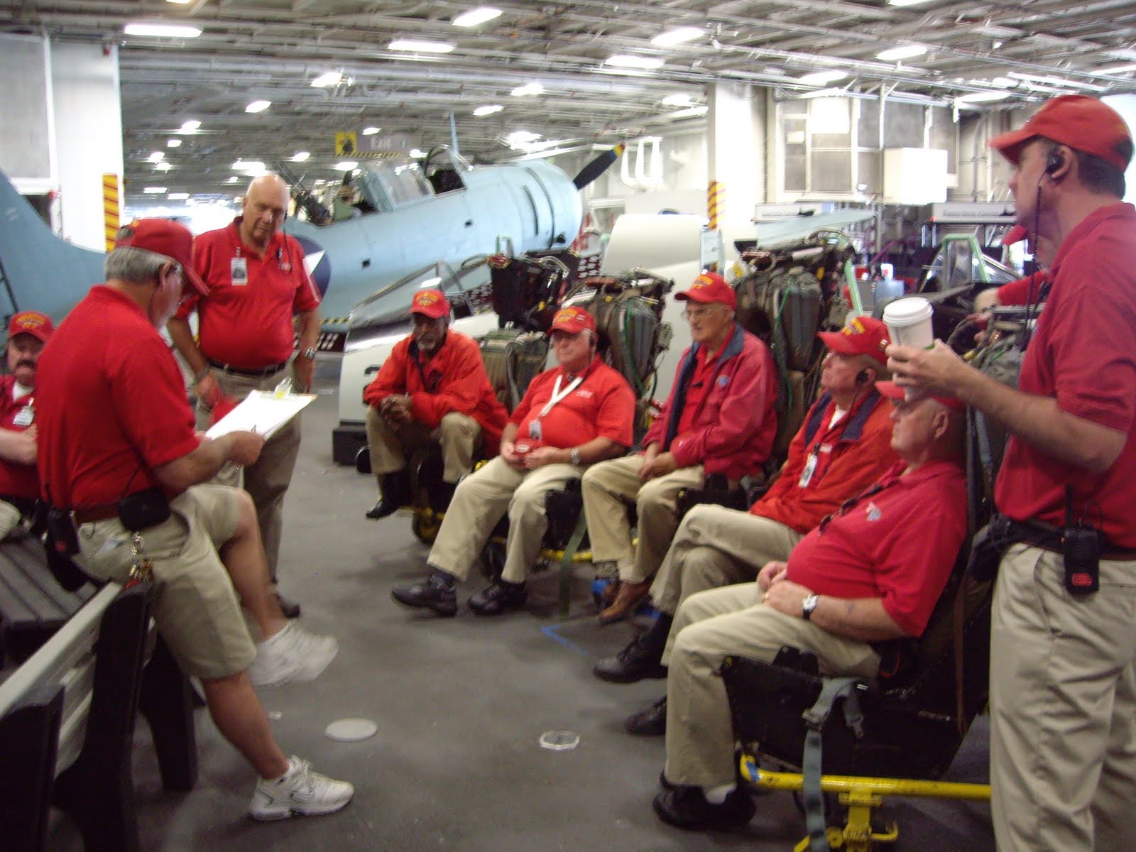
Sometime ago, I posted about volunteering on the USS Midway, a retired aircraft carrier, turned museum on San Diego Bay.  I continue working there several days a week when we're in town.  To date I've logged a little over 1000 hours on board and continue to enjoy my time spent there.  I work with the Safety Team, responsible for the safety of guests and employees on the ship.  If you've never paid a visit, I recommend that you do. Since becoming a museum over 6 million folks have been aboard and toured various areas both above and below decks.


SAFETY TEAM BRIEFING

MORNING LINEUP FOR TICKETS


BELOW DECKS

Here are a few facts about the Midway:

$90 million to build in 1945
2,000 feet of anchor chain
20 ton anchors
1,500 telephones
1,001 feet long
4-18 foot tall propellers
18 decks
3.4 million gallon fuel capacity
100,000 gallons used daily
260 gallons per mile
4500 crew members who ate:
10 tons of food each day
13,500 meals served each day
3,000 potatoes daily
1,000 loaves of bread daily
4,500 lbs. of beef when served
500 pies when served


Besides the normal day to day operation of a museum, the ship is used as a venue for parties, banquets, high school proms, and even weddings.  The other night the ship hosted "movie night" and was open for all comers free of charge.  We host many military events, such as retirements, promotions and re-enlistments.


OPERATION THIN MINT

ON OCCASION THE FLIGHT DECK IS STILL USED


RAFT-UP FOR THE AIR RACES

ANAHEIM PD MOTOR UNIT


ALEXANDRIA, MINNESOTA H.S. MARCHING BAND

So you see all kinds of things go on aboard the Midway.  Come on down a pay us a visit.  If you know me, drop me a line and I'll see about free tickets.