Monday, August 25, 2014

IOWA AND ILLINOIS

We spent three nights at Saylorville Lake, just north of Des Moines in some muggy mid-west weather. No rain, but hot and humid. From camp one can ride their bike into the city, which I did on one foggy morning. The city is so bike friendly that there are bike paths galore. The next morning I convinced Cathie to take a ride around the city, so we drove into town and rode many of the trails. Des Moines is a really beautiful and clean city, with parks and a great riverfront trail on both sides of the two rivers, the Des Moines and the Raccoon, that join in the downtown. Not much open for breakfast, but we managed to find the Ritual Cafe a vegetarian cafe run by a bunch of tattooed ladies that was pretty good.


 THE PAPAJOHN SCULPTURE PARK


Continuing on the Lincoln Highway theme, we reconnected with Hwy 30 and continued east. We crossed the Mississippi River at Clinton, Iowa and settled at Thomson Causeway, another great COE campground in the small town of Thomson. With a riverfront campsite, we opted to spend 4 nights instead of the planned 2. Also, once again, as with most of the trip so far, there is a great bike trail here that follows the river for 62 miles.


CAMP RESIDENTS


The Great River Trail is just part of the Grand Illinois Trail that covers more than 500 miles. Yes, I would like to, but it will have to wait. I rode most of the River Trail, but just like everywhere else, the weatherman doesn't always get it right. Supposed to have had clear skies in the morning, so I left around 6 am. After 35 miles or so, the skies opened up. First strong winds, then lightning and thunder and before I could find shelter, rain. Not the little might get you damp kind of rain, but soak you through in 1 minute rain. I managed to make it to a convenience store and for the price of a cup of coffee, they let me hang out until the rain stopped. Back on the bike to try and finish the trail but within two miles the skies became unfriendly once more. This time I found a restaurant and called Cathie for a rescue.

The next day, with the weatherman once again promising clear skies in the morning, I convinced Cathie to ride with me to Fulton, the next town downriver for a cup of coffee. It was a 15 mile round trip ride and we intended for it to be a leisurely one. We arrived in Fulton unscathed and found a nice little neighborhood cafe. While enjoying the coffee, Cathie observed that the sky to the west was looking mighty dark. "Not to worry", I said, "it's a long way off". We left the cafe and rode up on the river levee for some photos and then started back to camp.

Things went just fine till we reached about the halfway point. The wind started blowing pretty hard and then the rain started, sideways rain. Real heavy sideways rain. This was accompanied with lightning and thunder all around us. You know the system for telling how close the lightning is? After you see the lightning you count, one thousand one, one thousand two and so on until you hear the thunder, each one thousand representing a mile. So after the next flash of lightning I counted, "one thou" BOOM! With no place to take cover and riding on our lightning attracting metal bikes, we just rode faster, like we could outrun it. I've have never seen Cathie ride that fast. By the time we got back to camp we couldn't be any wetter, but we made it. Don't know if Cathie will be going on anymore rides with me though.

FULTON


This is the first attempt at a selfee on the river levee in town. Windmill Head didn't like it, so we took another.


There are yellow painted marks on the path to direct you on which way to go. For instance this means, turn right.

Whereas this means to go straight.

Similar to yellow arrows one follows on the Camino de Santiago in Spain

Of course any visit to the Mississippi, one must go see the barges traversing the locks. Tugs, push up to 12 barges up and down the river. When going through a lock, some locks will not accommodate 12 barges, so they must be separated and half are pushed through at a time, which takes over an hour. When loaded the barges draw 9 feet, so the COE keeps the river dredged just deep enough to accommodate them.

Notice this tug with it's bridge that can be raised and lowered on a hydraulic lift.


We saw some beautiful sunsets on the Mississippi before continuing east and stopping near Chicago for a few days.


We leave the Mississippi drive on our last segment of the Lincoln Highway as it passes through Chicago where we will park for a couple of days.


Thursday, August 14, 2014

MORE OF THE PLAINS

We've been hold up in a really nice city campground in Papillion, Nebraska called Walnut Creek. Papillion is a fast growing city just south of Omaha. The city campground is in a large park with walking and biking paths around a small lake. The campground portion as 40+ sites all with electric hookups for $16 a night. Lots of grass and room between campsites.


We discovered Papillion and it's campground when we were in the area in 2011. With bike paths leading all the way into the city of Omaha, all of which paved and separated from the roadway, it is a great place to ride. Many of the trails are on the top of creek and river levees and have mileage markers embedded in the pavement every 1/10 of a mile. So, I get up early and sneak out while Cathie sleeps and explore the trails, usually finding a place for coffee along the way.


Of course with a with all the bike riding one must regain their strength, so it was off to Big Mama's Kitchen for lunch. Located in what was once the cafeteria at the Nebraska School for the Deaf, Big Mama's has been a tremendous success. It's been featured on several programs on the Food Network including, Diner, Drive-ins and Dives.  It's become so popular that it is a stop for many tour bus companies.  When they arrive, Big Mama comes out of the kitchen and gives the group some details about how she started her restaurant.

BIG MAMA


I had the oven fried chicken, while Cathie opted for the same, but hers came smothered in country gravy. Now for more miles on the bike.

We took the short drive down to Lincoln, the state capitol, for a look at the capitol building.  Started in 1922 and completed 10 years later, the building came in just under the budget of 10 million.  We took a short guided tour and learned a very interesting fact about Nebraska's state government.

Nebraska's government started out much like any other state newly joined, in 1867 with the American union of states.  But, unlike all the others, it hasn't remained that way.  Following a referendum vote in 1934, Nebraska became the only state to operate with only one legislative body.  The 49 Senators who carry out the lawmaking duties are elected on a non-partisan basis.  There were arguments on both sides before and during the election, but today the general agreement is that the system is less expensive to operate, and that it more responsive to the needs and wants of the state's citizens.  Now, wouldn't it be something is the Federal Government operated in the same fashion.


SUPREME COURT

Behind the Judges bench in the Supreme Court is the following inscription:
         "EYES AND EARS ARE POOR WITNESSES WHEN THE SOUL IS BARBAROUS"

Since I had been riding so many miles on my bike, Cathie figured we could afford another lunch at Big Mama's Kitchen, as Friday's special was Chicken Fried Steak.  I reluctantly agreed.  We both agreed however that the Friday Special was much better than the Oven Fried Chicken that we had on our first visit.


To prevent any more meals with Big Mama and after a week in Papillion it was time to move on.  We our way back to the Lincoln Highway and headed into Iowa.  Our first stop and where we currently are for the next 3 nights is Saylorville Lake, just north of Des Moines.  We are in a very nice Army Corps of Engineers Campground.  Since it's a Federal Campground the Geezer Pass comes into play and we get to stay for $10 a night, with electrical hook-up. Once again there bike trails abound and it looks like a ride into the city is in the works.


Tuesday, August 12, 2014

A VISIT TO SKIDMORE, MISSOURI

Ok, you ask, what's in Skidmore? Well it's not what's in the small northern Missouri town, but what happened there. Every town has it's characters, some good, some bad. Skidmore had a bad one, in 46 year old Ken Rex McElory. McElory had numerous run-ins with the law and was charged with various crimes over the years. He was never convicted of his crimes as he had a habit of intimidating witnesses against him.


In 1980, one of McElroy's children got into an argument with a clerk, Evelyn Sumy, in a local grocery store owned by 70-year-old Ernest "Bo" Bowenkamp and his wife, Lois, allegedly because a younger McElroy child tried to steal some candy. McElroy began stalking the Bowenkamp family, and eventually threatened Bo Bowenkamp in the back of his store with a shotgun in hand. In the ensuing confrontation, McElroy shot Bowenkamp in the neck; Bowenkamp survived, and McElroy was arrested and charged with attempted murder. McElroy was convicted at trial of assault, but freed on bail pending his appeal. Immediately after being released at a post-trial hearing, McElroy went to the D&G Tavern, a local bar, with an M1 Garand rifle, and made graphic threats about what he would do to Mr. Bowenkamp. This led to several patrons deciding to see what they could legally do to prevent McElroy from harming anyone else. Nodaway County Sheriff Dan Estes suggested they form a Neighborhood Watch.
On the morning of July 10, 1981, after his appeal hearing was again delayed, townspeople met at the Legion Hall in the center of town with Sheriff Estes to discuss how to protect themselves. During the meeting, McElroy arrived at the D&G Tavern with Trena. As he sat drinking at the bar, word got back to the men at the Legion Hall that he was in town. After telling the assembled group not to get in a direct confrontation with McElroy, but instead seriously consider forming a Neighborhood Watch Program, Sheriff Estes drove out of town in his police cruiser. The citizens decided to go to the tavern en masse. The bar soon filled completely. After McElroy finished his drinks, he purchased a six pack of beer, left the bar, and entered his pickup truck. While McElroy was sitting in his truck he was shot at several times and hit twice, once by a center fire rifle and once by a .22 rimfire rifle. In all, there were 46 potential witnesses to the shooting, including Trena McElroy, who was in the truck with her husband when he was shot. No one called for an ambulance. Only Trena claimed to identify a gunman; every other witness either was unable to name an assailant or claimed not to have seen who fired the fatal shots. The DA declined to press charges. An extensive Federal investigation did not lead to any charges.
In 1988 a book, In Broad Daylight was written by Harry MacLean, which I read at the time. I was intrigued by the authors description of the town and the surrounding area. I specifically remember his description of the mud on the roadways left by the farm tractors. Later a movie of the same name was made starring Brian Dennehy as McElroy. Dennehy played a great villain in the movie. At the time I told myself that someday I would like to pay a visit to Skidmore. Well, now was the time. About 100 miles south of Omaha, we took a drive down to get a look for ourselves.

The population of Skidmore had declined in the ensuing years as has the town. The grocery has closed, no gas is sold at the service station, and the D&G Tavern is no more. Farming is still the main source of income in the area with corn and soy beans the main crops. At as we drove toward town, mud from the tractor tires was evident on the roads
.
In 1980 on the television show Dallas, J.R. Ewing was shot at the end of the season. CBS played up the next season with advertisements asking, "Who Shot J.R?"  Around the same time, after Ken Rex McElroy was shot, some one had T-shirts made up which on the front said, "Who Shot K.R?" and on the back said, "Who Cares".

ON THE WAY TO SKIDMORE


 NODAWAY COUNTY COURTHOUSE
IN MARYVILLE

You can buy the book In Broad Daylight on AMAZON

Sunday, August 10, 2014

THE PLAINS

We left Poudre River Canyon and headed out onto the plains. If you recall from your history and geography lessons in school, the plains start where the Rockies end. My reason for visiting the plains is because they are flat and I like flat when it comes to riding my bike. Sill alongside the Cashe La Poudre, between Winsor and Greeley, Colorado is one of Colorado’s many bike paths. The paved trail meanders beside the river, through farm land and the suburbs for 21 miles. So starting out in the cool of the morning I rode from the Greeley end for 19 miles and returned. Along the way I saw white pelicans, beaver, wild turkey, prairie dogs, a snake and the ever present rabbit. At an elevation of just under 5000 feet, I knew I had ridden 38 miles. The next morning I opted for a shorter segment with a stop for coffee at the halfway point.


THERE'S THAT SNAKE AGAIN

We pulled up stakes and continued our way east into Nebraska. The plan is to drive from North Platte, Nebraska to Chicago on US Highway 30, the Lincoln Highway. America’s first coast to coast highway, from New York to San Francisco, was first envisioned by Indianapolis businessman Carl Fisher, the man also responsible for the Indianapolis Motor Speedway and Miami Beach. With help from fellow industrialists Frank Seiberling and Henry Joy, an improved, hard-surfaced road was envisioned that would stretch almost 3400 miles from coast to coast over the shortest practical route. The Lincoln Highway Association was created in 1913 to promote the road using private and corporate donations. The idea was embraced by an enthusiastic public, and many other named roads across the country followed.  So we will be driving slow, exploring small town America and looking for remnants of the old highway.


Our first stop along the highway is Gothenburg, the Pony Express Capital of Nebraska. Founded in 1882 by Swedish immigrant Olof Bergstrom while working for the Union Pacific got the idea that a town was needed where Gothenburg now stands. Bergstrom traveled back to Sweden to convince his fellow countrymen to migrate to the United States, to build a new town in the west. He was very persuasive and by July of 1885 the town had a population of 300 and was incorporated.

As is common with small towns in the mid-west, many have camping facilities in their city park. Gothenburg was no different with 15 campsites with electrical, for $15 a night. A very nice shaded park with grass all around. Some towns offer the campsites for free.

TYPICAL SHADED STREET IN GOTHENBURG


After setting up in camp, we checked out the pony express station in it's original building. The building was originally used as a trading post and a ranch house, but in 1931 it was dismantled and reassembled in it's current location in the city park.

Heres another little tidbit of information about the town. Nebraska is corn country and the area surrounding Gothenburg is no different. There is a hugh rail shipping facility in Gothenburg owned by Frito Lay. Most of the corn in a 100 mile radius is trucked to Gothenburg and then shipped by rail to Frito Lay factories throughout the western US. So if your are eating a Frito in San Diego, the corn used to make your chip came from Gothenburg.

In the evening there was a knock on the RV door as the camp host was providing us with the location of the storm shelter, in the women's restroom. She informed us that there was a storm warning for severe thunderstorms. She said if we heard a siren we should head post haste to the shelter. She suggest that we bring a blanket with us. Later in the evening we could see the storms approaching with the clouds lit up with the lightening. Not like a thunderstorm that we experience in California, but a good mid-western thunderstorm with lightening that never stops flashing and hail that comes in 50 cent sizes.  The rain on the roof was so loud it was doubtful that the siren would be heard.

We survived with no damage and if the siren sounded, we slept through it.


Tuesday, August 05, 2014

GETTING HIGH IN COLORADO

We left home early a week ago Saturday and trying to beat the heat of the Mohave and the Utah desert, drove for two long days before arriving in the Rocky Mountains. We found a campsite of sorts in a national forest camp that consisted of a parking lot on the shores of Dillon Reservoir, which is just off of I-70 and about 70 miles east of Denver. The upside to this "camp" was its location.


Great views of the lake and the mountains beyond and close to the towns of Frisco, Dillon and Silverthorne. Take a good look at the blue sky in the photo taken the day of our arrival. The next four days it rained. But this is what is expected when we travel, the rain finds us.

The State of Colorado is not only home to legalized marijuana, but miles and miles of paved bike trails. We discovered several years ago that there were over 500 miles of these trails in the Denver area. Around here in the Rockies is no different, with paths connecting the towns in the area. I noticed a bike path alongside of I-70 most of the way over the Rockies. I had expected to ride some of these trails, but wimped out due to the rain.

Hiking trails abound here, mostly heading uphill. There are several 14,000 + peaks in the area, commonly referred to as 14 teeners, but they will have to wait for another time. We did manage to get in one hike between rain showers on a loop trail around Cataract Lake. A beautiful lake at about 9,000 feet.


Next we opted to forgo the interstate and stuck to the secondary routes heading north. We stopped off at State Forest State Park, which is just south of the Wyoming State line. An area known for spotting moose, but of course we didn't see any. While on a backcountry hike we happened upon a herd of elk, which heard us before we saw them. There we about 20 of them and they were up and over a ridge before I could get the camera out. I did manage to get a shot of a straggler who hung back to check us out.


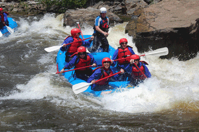
Friends and fellow bloggers, Don and Dorothy were in the region recently and wrote of their discovery of the Cache La Poudre River Canyon just west of Fort Collins. (You can read their blog HERE.)  Their description of the area was such that we just had to check it out. By heading west on Colorado 14 we climbed up over the Continental Divide and into the aforementioned canyon. The road drops some 5,000 feet in 50 miles as it follows the Cache La Poudre River. Campsites are plentiful as are the folks who occupy them, but by arriving on a Sunday many were returning home and we managed to snag a nice spot within earshot of the river. Cache La Poudre is French for "hide the powder, so named when in the 1820's French trappers, caught by a snowstorm were forced to bury part of their gun powder along the banks of the river. Today the river is popular with fishing, rafting and kayaking.


We paid a visit to Deadman Fire Lookout, now a National Historic Site. The tower has not been permanently staffed since 1970, but is operational and open to the public in the summer thanks to a crew of volunteers. The original wooden tower was built by the CCC in 1937 and was said to have swayed in the wind. It was replaced by the current metal structure in 1961. At a height of 55 feet to the lookout platform and an elevation of 10,710, I managed to overcome my fear of heights. I only made it to the top by white knuckling the stair rails and keeping focused on Cathie's derriere as she led the way.  There is proof that I made it to the top as I took this photo of Cathie in the lookout.


We are now in Greeley, Colorado for three days to resupply, do laundry and hopefully get some bike riding in. There is a great 21 mile bike path along the Cache La Poudre River between here and Fort Collins. Let's hope it doesn't rain.